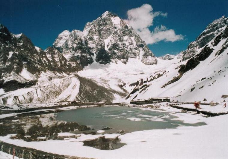
Manimahesh Kailash Lake &
Difficult Alpine Trail in Chamba • Summit 4,080 m • 4–5 Days
Alpine Field Dossier • Route Metrics
About Manimahesh Kailash Lake & Trek
One of the most sacred high-altitude pilgrimage treks in the Indian Himalayas, leading to the glacial tarn of Manimahesh Lake (4,080m) resting immediately beneath the unclimbed, pyramidal summit of Manimahesh Kailash (5,653m). Undertaken annually during the sacred Janmashtami and Radhashtami fairs, the trail climbs steeply from Hadsar through steep alpine gorges, glacial moraines, and the high pasture of Gauri Kund.
Trailhead Approach
Commences from Base Trailhead, following established mountain corridors through valley topography.
Alpine Progression
Rises steadily into open mountain zones with panoramic vantages across Chamba.
High Vantage & Crest
Reaches high elevation vantage points where disciplined alpine pacing and weather awareness ensure a safe journey.
The Route
Trailhead coordinates, navigation milestones, and geospatial profile connecting Base Trailhead to the summit crest.
Base Trailhead
Chamba, Himachal Pradesh • Trailhead Access
Manimahesh Kailash Lake & Trek (4,080 m)
Panoramic vistas from Manimahesh Kailash Lake & Trek across Chamba
32.4042° N, 76.6347° E
Mapped trail route
Interactive 3D Satellite Terrain
Inspect the 3D glacial topography, ridge relief, and trail approaches of Manimahesh Kailash Lake & Trek in photorealistic satellite imagery.
Elevation Profile
Continuous vertical gradient from Base Trailhead to the 4,080 m summit crest with live slope & oxygen estimates.
Elevation Milestones • 4,080 m Apex
- Base Trailhead
- Base Trailhead
- Mid-Trail Stage
- Mid-Elevation Stage
- Apex Summit Marker
- Manimahesh Kailash Lake & Trek • 4,080 m
Information
Everything you need for a safe and prepared journey — real-time weather, seasonal cycles, practical field tips, medical directives, and gear checklist.
Best Time & Live Mountain Weather
Summer & Spring (May – June)
Clear morning skies, blooming alpine meadows across Chamba, and comfortable daytime trekking conditions with residual high pass snow.
Monsoon (July – August)
Lush green valley trails and vibrant mountain ecology. Afternoon showers require early morning departures and waterproof shells.
Post-Monsoon / Autumn (Sept – Oct)
Unparalleled long-range visibility, stable atmospheric pressure, and crisp dry conditions across the Himalayan summits.
Winter & Early Spring (Nov – April)
High elevation terrain covered in heavy seasonal snow. Lower valley trails accessible; high cols demand specialized cold-weather preparation.
Trail Tips & Practical Advice
Acclimatize thoroughly in Bharmour (2,195m) for at least 24 hours before beginning the steep trek from Hadsar.
Weather is extremely fickle; freezing rain, hail, and high winds are frequent even during peak summer pilgrimage season. Carry complete waterproofs.
Altitude Safety & Emergency Protocols
The Three Golden Rules of Altitude Safety
- 1Rule 1: Any headache or illness above 2,500m is Acute Mountain Sickness (AMS) until proven otherwise.
- 2Rule 2: Never ascend to sleep at a higher campsite with symptoms of altitude sickness.
- 3Rule 3: If symptoms worsen, or if ataxia (loss of balance) or breathlessness at rest appears, descend immediately.
What to Pack
Recommended alpine gear and equipment essentials required for the Manimahesh Kailash Lake & Trek route.
Frequently Asked Questions
Clear answers regarding distance, altitude, how to reach, opening hours, winter conditions, and permits for Manimahesh Kailash Lake & Trek.
More Trails in Chamba
Continue your journey through neighboring valleys, glacier basins, and trails across Chamba.
Dalhousie & Dainkund Peak
Perched along the Dhauladhar ridgeline, Dalhousie is an iconic colonial-era alpine hill retreat surrounded by towering deodar forests. The trail to Dainkund Peak (2,755m)—known as the Singing Hill—offers a sweeping 360-degree panorama of the Chenab, Ravi, and Beas river basins and the snow-clad Pir Panjal range.
Khajjiar Meadow & Lake
Often celebrated as the 'Mini Switzerland of India', Khajjiar is a saucer-shaped glade nestled within dense deodar and fir forests. At its heart lies a small tranquil lake with a floating island of reed grass, framed by the 12th-century wooden temple of Khajji Nag with intricately carved serpent motifs.
Bharmour & Chaurasi Temples
Historically known as Brahmpura, Bharmour was the ancient 6th-century capital of the Chamba kingdom and is the sacred spiritual heartland of the nomadic Gaddi shepherds. The town centers around the legendary Chaurasi Temple complex—a sanctified courtyard of 84 ancient stone shrines dating back over 1,400 years, anchored by the iconic Manimahesh and Lakshana Devi temples.